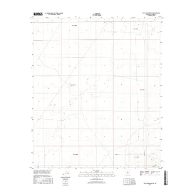
2017 Map of Tres Hermanos SW
USGS Topo · Published 2017About this map
The southern reaches of the Jarilla Mountains dominate the southeastern corner of this Otero County landscape, providing a stark topographical contrast to the expansive, relatively flat basin floor that covers most of the quadrangle. These foothills are accessed via Co Rd A011, which skirts the mountain base. Further north and west, the terrain is characterized by subtle drainage patterns and isolated water features like North Tank, highlighting the arid nature of this region. Much of the infrastructure shown reflects the military and administrative management of the area, specifically with corridors such as Wsmr S Rt 259 and Wsmr S Rt 252 crossing the desert floor. This 2017 survey delineates the Township and Range boundaries across the T19S, T20S, and T21S sections, documenting the modern survey grid in a territory defined by high-desert land management.
Find a feature on this map
11 named features on this map. Tap any name to fly to it.
Don’t see what you’re looking for? This feature index may not catch every label — zoom into the map to look around manually.
Map Details
Editions of this 2017 Tres Hermanos SW Map
This is the sole edition of this map. No revisions or reprints were ever made.
Other maps of this area

1916 · Point Of Sands
USGS Topo · 1:125,000

1940 · Orogrande
USGS Topo · 1:62,500

1943 · Parker Lake
USGS Topo · 1:62,500

1943 · Orogrande
USGS Topo · 1:62,500

1947 · Orogrande North
USGS Topo · 1:24,000

1947 · Lake Lucero
USGS Topo · 1:62,500

1948 · Elephant Mountain
USGS Topo · 1:24,000
1948 · Parker Lake NE
USGS Topo · 1:24,000

1948 · Tres Hermanos
USGS Topo · 1:62,500

1948 · Lake Lucero SE
USGS Topo · 1:24,000