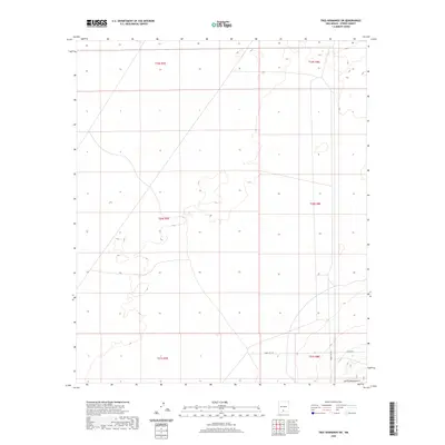
2020 Map of Tres Hermanos SW
USGS Topo · Published 2020About this map
The Jarilla Mountains rise from the southern reaches of this landscape in Otero County, marking a distinct break in the desert floor. This 2020 survey documents a transition between public land and controlled military access, primarily defined by the intersections of Wsmr S Rt 259 and Wsmr S Rt 252. The map illustrates the structured township and range system, including t21s r8e and t20s r7e, which partition the arid terrain. While largely open space, the presence of Co Rd A011 provides a local reference point for navigation through this high-desert region, situated within a broader network of government reservations and managed lands.
Find a feature on this map
10 named features on this map. Tap any name to fly to it.
Don’t see what you’re looking for? This feature index may not catch every label — zoom into the map to look around manually.
Map Details
Editions of this 2020 Tres Hermanos SW Map
This is the sole edition of this map. No revisions or reprints were ever made.
Other maps of this area

1916 · Point Of Sands
USGS Topo · 1:125,000

1940 · Orogrande
USGS Topo · 1:62,500

1943 · Parker Lake
USGS Topo · 1:62,500

1943 · Orogrande
USGS Topo · 1:62,500

1947 · Orogrande North
USGS Topo · 1:24,000

1947 · Lake Lucero
USGS Topo · 1:62,500

1948 · Elephant Mountain
USGS Topo · 1:24,000
1948 · Parker Lake NE
USGS Topo · 1:24,000

1948 · Tres Hermanos
USGS Topo · 1:62,500

1948 · Lake Lucero SE
USGS Topo · 1:24,000