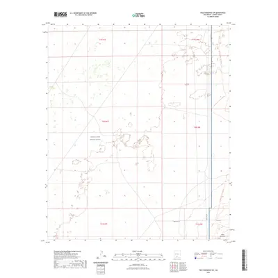
2023 Map of Tres Hermanos SW
USGS Topo · Published 2023About this map
The White Sands Missile Range dominates this portion of Otero County, marking a landscape defined by restricted federal usage and specialized infrastructure. The map details the transition from open desert terrain into the foothills of the Jarilla Mountains in the southeast corner. Transportation through this arid environment is facilitated by restricted military routes such as WSMR S Rt 252 and WSMR S Rt 259, alongside local access provided by Co Rd A011.
Find a feature on this map
13 named features on this map. Tap any name to fly to it.
Don’t see what you’re looking for? This feature index may not catch every label — zoom into the map to look around manually.
Map Details
Editions of this 2023 Tres Hermanos SW Map
This is the sole edition of this map. No revisions or reprints were ever made.
Other maps of this area

1916 · Point Of Sands
USGS Topo · 1:125,000

1940 · Orogrande
USGS Topo · 1:62,500

1943 · Parker Lake
USGS Topo · 1:62,500

1943 · Orogrande
USGS Topo · 1:62,500

1947 · Orogrande North
USGS Topo · 1:24,000

1947 · Lake Lucero
USGS Topo · 1:62,500

1948 · Elephant Mountain
USGS Topo · 1:24,000
1948 · Parker Lake NE
USGS Topo · 1:24,000

1948 · Tres Hermanos
USGS Topo · 1:62,500

1948 · Lake Lucero SE
USGS Topo · 1:24,000