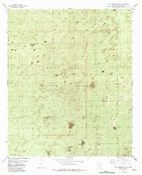
1982 Map of Tres Hermanos SW
USGS Topo · Published 1982About this map
The White Sands Missile Range dominates this 1982 orthophotomosaic, revealing the intersection of high-technology defense and the desert landscape of Otero County. This unique survey combines traditional topographic contours with aerial photography, capturing the specialized infrastructure of the Cold War era. Distinct technical installations such as the Ram Site, Rampart Site, Key Site, and Amrad Site are scattered across the terrain, indicating a landscape of active research and monitoring.
Find a feature on this map
12 named features on this map. Tap any name to fly to it.
Don’t see what you’re looking for? This feature index may not catch every label — zoom into the map to look around manually.
Map Details
Editions of this 1982 Tres Hermanos SW Map
This is the sole edition of this map. No revisions or reprints were ever made.
Other maps of this area

1916 · Point Of Sands
USGS Topo · 1:125,000

1940 · Orogrande
USGS Topo · 1:62,500

1943 · Parker Lake
USGS Topo · 1:62,500

1943 · Orogrande
USGS Topo · 1:62,500

1947 · Orogrande North
USGS Topo · 1:24,000

1947 · Lake Lucero
USGS Topo · 1:62,500

1948 · Elephant Mountain
USGS Topo · 1:24,000
1948 · Parker Lake NE
USGS Topo · 1:24,000

1948 · Tres Hermanos
USGS Topo · 1:62,500

1948 · Lake Lucero SE
USGS Topo · 1:24,000