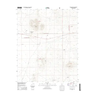
2013 Map of Tres Montosas
USGS Topo · Published 2013About this map
Cibola National Forest defines the character of this landscape in Socorro County, where high desert terrain meets established cattle ranching territory. The map centers on the prominent Tres Montosas peaks, a landmark formation that overlooks the surrounding arroyos and canyons. Transport through this region is marked by the alignment of modern US Hwy 60 alongside traces of the Old Highway 60 and Old Highway 52, illustrating the evolution of New Mexico's road network. This survey captures the working landscape of the early 21st century, identifying isolated ranching outposts such as Evans Ranch, Montosa Camp, and Cat Mountain Ranch. The drainage patterns are meticulously detailed, from the broad Milligan Gulch to the seasonal courses of Arroyo Montosa and Arroyo Landavaso. Land management boundaries for the national forest intersect with private holdings and prominent physical features like Gray Hill and Cat Mtn.
Find a feature on this map
21 named features on this map. Tap any name to fly to it.
Don’t see what you’re looking for? This feature index may not catch every label — zoom into the map to look around manually.
Map Details
Editions of this 2013 Tres Montosas Map
This is the sole edition of this map. No revisions or reprints were ever made.
Other maps of this area

1954 · Tularosa
USGS Topo · 1:250,000

1954 · Socorro
USGS Topo · 1:250,000

1958 · Socorro
USGS Topo · 1:250,000

1958 · Tularosa
USGS Topo · 1:250,000

1962 · Socorro
USGS Topo · 1:250,000

1963 · Arroyo Landavaso
USGS Topo · 1:24,000

1964 · Arrowhead Well
USGS Topo · 1:24,000

1964 · Monica Saddle
USGS Topo · 1:24,000

1964 · Silver Hill
USGS Topo · 1:24,000

1964 · Tres Montosas
USGS Topo · 1:24,000