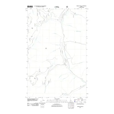
2011 Map of Trestle Peak
USGS Topo · Published 2011About this map
Auxor Mine sits high in the Auxor Basin, representing a legacy of extraction within this steep mountain drainage of northern Idaho. The landscape is defined by the sharp elevations of Trestle Peak and Trestle Ridge, which divide a dense network of watercourses including Trestle Creek and Smorgasbord Creek. A complex system of Forest Service roads, notably Nat For Dev Rd 419 and Wellington Creek Rd, provides the primary access through these ridges. To the east, Lightning Creek flows through the canyon, joined by numerous tributaries like Mink Creek and Rattle Creek. The presence of a Waterfall near Lunch Creek and the high-elevation Blacktail Lake underscore the verticality and drainage patterns of this high country as it was surveyed at the start of the 21st century.
Find a feature on this map
33 named features on this map. Tap any name to fly to it.
Don’t see what you’re looking for? This feature index may not catch every label — zoom into the map to look around manually.
Map Details
Editions of this 2011 Trestle Peak Map
This is the sole edition of this map. No revisions or reprints were ever made.
Other maps of this area

1911 · Priest Lake
USGS Topo · 1:250,000

1913 · Priest Lake
USGS Topo · 1:250,000

1949 · Packsaddle Mtn
USGS Topo · 1:62,500

1951 · Packsaddle Mtn
USGS Topo · 1:62,500

1951 · Clark Fork
USGS Topo · 1:62,500

1951 · Mt Pend Oreille
USGS Topo · 1:62,500

1951 · Elmira
USGS Topo · 1:62,500

1958 · Sandpoint
USGS Topo · 1:250,000

1963 · Sandpoint
USGS Topo · 1:250,000
1984 · Sandpoint
USGS Topo · 1:100,000