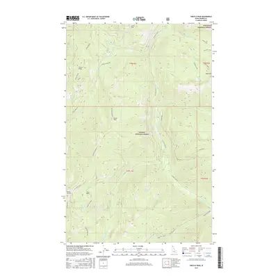
2017 Map of Trestle Peak
USGS Topo · Published 2017About this map
Trestle Ridge and the high mountain terrain of Bonner County define this landscape at the intersection of the Kaniksu National Forest and Kootenai National Forest. The map is centered on a series of peaks including Trestle Peak, Lunch Peak, and Round Top Mtn, illustrating a region dominated by forestry and remote industrial activity. The presence of the Auxor Mine Div within the Auxor Basin highlights the mining heritage of these mountains, while a network of service routes like Lightning Creek Rd and the Trestle Creek Rd provide the primary access through the drainages of Lightning Creek and Wellington Creek. This 2017 edition documents the backcountry geography and high-elevation water bodies like Moose Lake and Blacktail Lake, serving as a detailed record of the ridgelines and creek beds that shape the Cabinet Mountains region.
Find a feature on this map
45 named features on this map. Tap any name to fly to it.
Don’t see what you’re looking for? This feature index may not catch every label — zoom into the map to look around manually.
Map Details
Editions of this 2017 Trestle Peak Map
This is the sole edition of this map. No revisions or reprints were ever made.
Other maps of this area

1911 · Priest Lake
USGS Topo · 1:250,000

1913 · Priest Lake
USGS Topo · 1:250,000

1949 · Packsaddle Mtn
USGS Topo · 1:62,500

1951 · Packsaddle Mtn
USGS Topo · 1:62,500

1951 · Clark Fork
USGS Topo · 1:62,500

1951 · Mt Pend Oreille
USGS Topo · 1:62,500

1951 · Elmira
USGS Topo · 1:62,500

1958 · Sandpoint
USGS Topo · 1:250,000

1963 · Sandpoint
USGS Topo · 1:250,000
1984 · Sandpoint
USGS Topo · 1:100,000