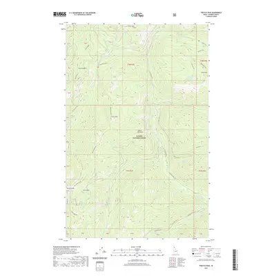
2020 Map of Trestle Peak
USGS Topo · Published 2020About this map
The Cabinet Mountains dominate this high-elevation landscape within the Kaniksu National Forest, where steep drainages and mountain peaks define the topography. In the southwest corner of the sheet, researchers can identify the Auxor Basin and the associated Auxor Mine Ohr, indicating the historic mining activity that once drew prospectors to these heights. The area is intersected by several forest roads, including Trestle Creek Rd and Lightning Creek Rd, which follow the primary watercourses through the timbered terrain. Notable summits like Trestle Peak, Lunch Peak, and Moose Mtn provide orientation points, while alpine waters like Moose Lake and Blacktail Lake occupy the eastern portion of the quadrangle. The map also delineates the Beetop-Roundtop trail system, reflecting the balance between resource extraction and the recreational use of this portion of Bonner County.
Find a feature on this map
56 named features on this map. Tap any name to fly to it.
Don’t see what you’re looking for? This feature index may not catch every label — zoom into the map to look around manually.
Map Details
Editions of this 2020 Trestle Peak Map
This is the sole edition of this map. No revisions or reprints were ever made.
Other maps of this area

1911 · Priest Lake
USGS Topo · 1:250,000

1913 · Priest Lake
USGS Topo · 1:250,000

1949 · Packsaddle Mtn
USGS Topo · 1:62,500

1951 · Packsaddle Mtn
USGS Topo · 1:62,500

1951 · Clark Fork
USGS Topo · 1:62,500

1951 · Mt Pend Oreille
USGS Topo · 1:62,500

1951 · Elmira
USGS Topo · 1:62,500

1958 · Sandpoint
USGS Topo · 1:250,000

1963 · Sandpoint
USGS Topo · 1:250,000
1984 · Sandpoint
USGS Topo · 1:100,000