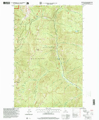
1996 Map of Trestle Peak
USGS Topo · Published 1999About this map
Kaniksu National Forest defines this high-elevation Idaho landscape, where steep drainages and mountain ridges dictate the pattern of human activity. The map reveals a legacy of mineral exploration centered around the Auxor Basin, featuring the Auxor Mine, a Prospect, and an Open Pit Mine south of Round Top Mountain. This area is carved by a dense network of watercourses including Lightning Creek and Trestle Creek, which feed into the larger regional watershed. Recreational and utilitarian access is marked by the Sherpa Trail and Alpine Trail, navigating the terrain between Trestle Peak and Lunch Peak. The presence of several lookout points and a Gravel Pit near Rattle Creek suggests the ongoing importance of forest management and resource extraction in the late twentieth century.
Find a feature on this map
33 named features on this map. Tap any name to fly to it.
Don’t see what you’re looking for? This feature index may not catch every label — zoom into the map to look around manually.
Map Details
Editions of this 1996 Trestle Peak Map
This is the sole edition of this map. No revisions or reprints were ever made.
Other maps of this area

1911 · Priest Lake
USGS Topo · 1:250,000

1913 · Priest Lake
USGS Topo · 1:250,000

1949 · Packsaddle Mtn
USGS Topo · 1:62,500

1951 · Packsaddle Mtn
USGS Topo · 1:62,500

1951 · Clark Fork
USGS Topo · 1:62,500

1951 · Mt Pend Oreille
USGS Topo · 1:62,500

1951 · Elmira
USGS Topo · 1:62,500

1958 · Sandpoint
USGS Topo · 1:250,000

1963 · Sandpoint
USGS Topo · 1:250,000
1984 · Sandpoint
USGS Topo · 1:100,000