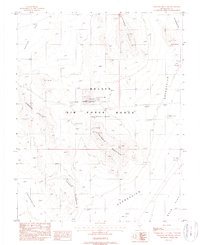
1988 Map of Triangle Mountain
USGS Topo · Published 1988About this map
The Nellis Air Force Range (Restricted Area) dominates this high-desert landscape in Nye County, Nevada, reflecting the region's mid-century transition to a dedicated military testing and training zone. The terrain is defined by a series of distinct geological formations, including the prominent Triangle Mountain and the sweeping Coyote Cuesta. In the northern section, the Lizard Hills rise above Cactus Flat, while the southern expanse transitions into the broad reach of Gold Flat. This 1988 provisional map documents the restricted land use of the era, noting a specific Gold Mountain peak and several unnamed landing sites or observation points within the military boundaries. The lack of civilian infrastructure, such as towns or commercial roads, underscores the isolated, tactical nature of this specific quadrant of the Nevada desert during the late Cold War period.
Find a feature on this map
11 named features on this map. Tap any name to fly to it.
Don’t see what you’re looking for? This feature index may not catch every label — zoom into the map to look around manually.
Map Details
Editions of this 1988 Triangle Mountain Map
This is the sole edition of this map. No revisions or reprints were ever made.
Other maps of this area

1908 · Kawich
USGS Topo · 1:250,000

1942 · Tolicha Peak
USGS Topo · 1:125,000

1942 · Cactus Range
USGS Topo · 1:125,000

1942 · Reveille Peak
USGS Topo · 1:125,000

1942 · Wheelbarrow Peak
USGS Topo · 1:125,000

1952 · Mellan
USGS Topo · 1:62,500

1952 · Quartzite Mtn
USGS Topo · 1:62,500

1952 · Silent Canyon
USGS Topo · 1:62,500
1952 · Black Mtn
USGS Topo · 1:62,500

1954 · Goldfield
USGS Topo · 1:250,000