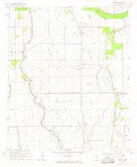
1967 Map of Tribbett
USGS Topo · Published 1981About this map
Meandering waterways like Bogue Phalia and Sixmile Bayou define the agricultural landscape of Washington and Sunflower Counties in the late 1960s. The settlement pattern is deeply rooted in local community institutions, evidenced by a dense network of country churches and cemeteries such as Kindling Altar Ch and Bethlehem Cem. Significant evidence of early habitation is found in the northern portion of the map at the Indian Mounds near the Bogue Phalia Cutoff. Small rural centers like Tribbett, Bourbon, and Tralake serve as anchors in a terrain marked by complex drainage features like Deep Slough and Cypress Slough. The map also documents modern utility and transport infrastructure, from a prominent Radio Tower to a local Landing Strip, illustrating the evolution of the Mississippi Delta's rural economy.
Find a feature on this map
28 named features on this map. Tap any name to fly to it.
Don’t see what you’re looking for? This feature index may not catch every label — zoom into the map to look around manually.
Map Details
Editions of this 1967 Tribbett Map
2 editions found
Other maps of this area

1939 · Tralake
USGS Topo · 1:62,500

1939 · Swan Lake
USGS Topo · 1:62,500

1940 · Auter
USGS Topo · 1:62,500

1940 · Baird
USGS Topo · 1:62,500

1953 · Greenwood
USGS Topo · 1:250,000

1956 · Greenwood
USGS Topo · 1:250,000

1965 · Indianola
USGS Topo · 1:24,000

1965 · Kinlock
USGS Topo · 1:24,000
1965 · Midnight NW
USGS Topo · 1:24,000

1967 · Baird
USGS Topo · 1:62,500