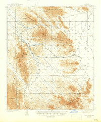
1939 Map of Trigo Peaks
USGS Topo · Published 1947About this map
The Gila and Salt River Base Line cuts across this arid landscape in Yuma County, establishing a primary survey reference point amid a complex system of mountains and washes. The topography is dominated by the North Trigo Peaks and South Trigo Peaks, which rise sharply above the La Posa Plain. Water management in this desert environment is recorded through scattered landmarks such as White Tanks and Mohave Tanks, essential stopping points for travelers moving through the high passes. Historically, the area facilitated transit via the Cibola Road, which winds through the Trigo Mountains. Resource extraction is evidenced by the Tweed Mine located in the southern reaches of the quadrangle. The map details a network of dry drainages, including Trigo Wash and Mohave Wash, which define the erosion patterns of the Dome Rock Mountains and the northern Chocolate Mountains.
Find a feature on this map
25 named features on this map. Tap any name to fly to it.
Don’t see what you’re looking for? This feature index may not catch every label — zoom into the map to look around manually.
Map Details
Editions of this 1939 Trigo Peaks Map
2 editions found
Other maps of this area

1933 · Cunningham Mtn
USGS Topo · 1:48,000

1934 · Trigo Peaks
USGS Topo · 1:48,000

1939 · Red Hill
USGS Topo · 1:62,500

1939 · Trigo Peaks
USGS Topo · 1:62,500

1940 · Dome Rock Mts
USGS Topo · 1:62,500

1942 · Blythe
USGS Topo · 1:250,000

1945 · Cibola
USGS Topo · 1:62,500

1945 · Picacho
USGS Topo · 1:62,500

1951 · Picacho
USGS Topo · 1:62,500

1951 · Blythe
USGS Topo · 1:24,000