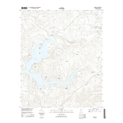
2014 Map of Trimble
USGS Topo · Published 2014About this map
Lewis Smith Lake dominates the topography of this portion of Cullman County, its complex, winding shoreline creating numerous peninsulas such as Catalina Point and Dogwood Point. The landscape is a mix of these extensive waterways and small rural communities like Trimble and Loretto, which are interconnected by a dense network of county roads. For genealogists and local historians, the map is a significant record of the area's rural heritage, noting several family and community burial grounds including Sharon Grove Cem, Brushy Creek Cem, and Kinneys Grove Cem. The settlement pattern follows the high ground between the various creek branches, with Good Hope and Dodge City serving as more concentrated hubs of activity away from the immediate lakefront. The presence of Schmmuck Mtn and Bailey Mtn provides a clear view of the elevation changes that define the drainage basins of Ryan Creek and Simpson Cr.
Find a feature on this map
152 named features on this map. Tap any name to fly to it.
Don’t see what you’re looking for? This feature index may not catch every label — zoom into the map to look around manually.
Map Details
Editions of this 2014 Trimble Map
This is the sole edition of this map. No revisions or reprints were ever made.
Other maps of this area

1888 · Cullman
USGS Topo · 1:125,000

1889 · Birmingham
USGS Topo · 1:125,000

1892 · Cullman
USGS Topo · 1:125,000

1892 · Birmingham
USGS Topo · 1:125,000

1893 · Jasper
USGS Topo · 1:125,000

1895 · Birmingham
USGS Topo · 1:125,000

1907 · Birmingham
USGS Topo · 1:125,000

1949 · Cold Springs
USGS Topo · 1:24,000

1951 · Cold Springs
USGS Topo · 1:24,000

1951 · Arkadelphia
USGS Topo · 1:24,000