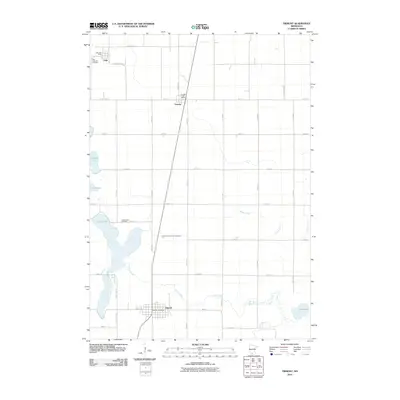
2010 Map of Trimont
USGS Topo · Published 2010About this map
The agricultural landscape of Martin and Watonwan Counties is anchored by the small town of Trimont, which serves as a central hub for the surrounding rural sections. The township's layout is defined by a rigorous grid of section roads and county highways that connect the outlying settlements of Odin and Ormsby. Hydrological features like Cedar Lake and Buffalo Lake punctuate the prairie, with Cedar Creek and Willow Creek draining the flatlands. For genealogists, the map identifies local burial grounds including Zion Lutheran Cemetery in the north and Cedar Lake Cemetery near the western shoreline. Public services remain localized at the Odin Post Office, Ormsby Post Office, and Trimont Post Office, reflecting the enduring community structure of this southern Minnesota region. The presence of Judicial Ditch Number Twentyone highlights the area's history of land management and drainage engineering necessary for large-scale cultivation.
Find a feature on this map
32 named features on this map. Tap any name to fly to it.
Don’t see what you’re looking for? This feature index may not catch every label — zoom into the map to look around manually.
Map Details
Editions of this 2010 Trimont Map
This is the sole edition of this map. No revisions or reprints were ever made.
Other maps of this area

1954 · Fairmont
USGS Topo · 1:250,000

1958 · Fairmont
USGS Topo · 1:250,000

1970 · St James SE
USGS Topo · 1:24,000
1970 · Butterfield
USGS Topo · 1:24,000
1970 · St James West
USGS Topo · 1:24,000

1970 · Trimont
USGS Topo · 1:24,000

1970 · Mountain Lake SE
USGS Topo · 1:24,000
1970 · St James East
USGS Topo · 1:24,000

1970 · Welcome
USGS Topo · 1:24,000

1970 · Sherburn
USGS Topo · 1:24,000