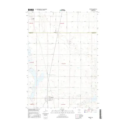
2016 Map of Trimont
USGS Topo · Published 2016About this map
Trimont serves as the primary hub in this agricultural landscape on the border of Watonwan and Martin Counties. The town's grid is detailed with street names like Beech St E and Apple St E, while the surrounding prairie is defined by a dense network of township roads and water management features such as Judicial Ditch Number Twentyone. To the north, the settlements of Odin and Ormsby mark the northern reaches of the quadrangle, connected by the long straight line of Broadway. A significant chain of water bodies, including Cedar Lake, Buffalo Lake, Fish Lake, and North Lake, creates a distinct north-south corridor through the western half of the map. Near the center of this chain sits the Cedar Lake Cem, a focal point for local genealogy and history. The eastern portion of the sheet is dominated by meandering waterways like Willow Cr and Elm Cr, which cut through the patterned fields of the Minnesota countryside.
Find a feature on this map
57 named features on this map. Tap any name to fly to it.
Don’t see what you’re looking for? This feature index may not catch every label — zoom into the map to look around manually.
Map Details
Editions of this 2016 Trimont Map
This is the sole edition of this map. No revisions or reprints were ever made.
Other maps of this area

1954 · Fairmont
USGS Topo · 1:250,000

1958 · Fairmont
USGS Topo · 1:250,000

1970 · St James SE
USGS Topo · 1:24,000
1970 · Butterfield
USGS Topo · 1:24,000
1970 · St James West
USGS Topo · 1:24,000

1970 · Trimont
USGS Topo · 1:24,000

1970 · Mountain Lake SE
USGS Topo · 1:24,000
1970 · St James East
USGS Topo · 1:24,000

1970 · Welcome
USGS Topo · 1:24,000

1970 · Sherburn
USGS Topo · 1:24,000