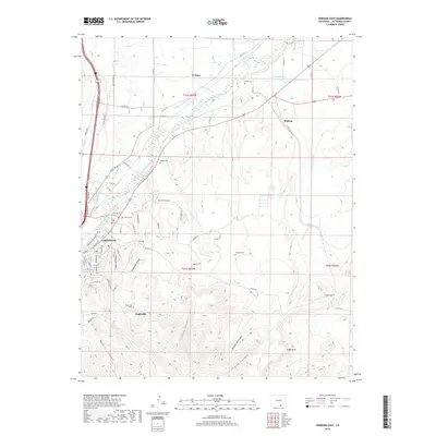
2019 Map of Trinidad East
USGS Topo · Published 2019About this map
The Purgatoire River carves through this Las Animas County landscape, where the urban edge of Trinidad meets a series of outlying settlements and historic family burial grounds. The transition from the river valley to the southern high ground is marked by complex terrain including Engleville Canyon, China Canyon, and Nile Canyon. Cultural landmarks are scattered throughout the quadrangle, from the settlement of Engleville and its associated Engleville Cem to the north-side communities of El Moro and Beshoar. This late-2010s survey shows a detailed irrigation and water management network, featuring the Model Intake Canal, Johns Ditch, and Picketwire Ditch. These waterways support the agricultural flats surrounding Rivera Cem and Valdez Cem, reflecting the area's long-standing connection between its water sources and its residential clusters.
Find a feature on this map
83 named features on this map. Tap any name to fly to it.
Don’t see what you’re looking for? This feature index may not catch every label — zoom into the map to look around manually.
Map Details
Editions of this 2019 Trinidad East Map
This is the sole edition of this map. No revisions or reprints were ever made.
Other maps of this area

1891 · Spanish Peaks
USGS Topo · 1:125,000

1892 · Elmoro
USGS Topo · 1:125,000

1893 · Spanish Peaks
USGS Topo · 1:125,000

1893 · Elmoro
USGS Topo · 1:125,000

1895 · Spanish Peaks
USGS Topo · 1:125,000

1897 · Elmoro
USGS Topo · 1:125,000

1897 · Spanish Peaks
USGS Topo · 1:125,000

1900 · Spanish Peaks
USGS Topo · 1:125,000

1951 · Trinidad
USGS Topo · 1:24,000
1951 · Starkville
USGS Topo · 1:24,000