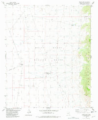
1981 Map of Trinity Site
USGS Topo · Published 1982About this map
The Trinity Site Historical Landmark stands at the center of this landscape, marking the ground within the White Sands Missile Range where the first atomic device was detonated. This survey captures the site and its surrounding military infrastructure in the early 1980s, including the Observation Towers Millars Watch Site located to the southeast. The geography is defined by the high elevations of the Oscura Mountains to the east and the sparse, arid basin floor. Access is limited to the Government Road, which cuts across the high desert terrain. Human presence beyond the military mission is represented by few features, such as the Beck Site and water sources like Story East Tank and Trail Canyon Well, which are critical markers in this remote environment of the Tularosa Basin.
Find a feature on this map
11 named features on this map. Tap any name to fly to it.
Don’t see what you’re looking for? This feature index may not catch every label — zoom into the map to look around manually.
Map Details
Editions of this 1981 Trinity Site Map
This is the sole edition of this map. No revisions or reprints were ever made.
Other maps of this area

1918 · Oscura Peak
USGS Topo · 1:125,000

1948 · Carthage
USGS Topo · 1:62,500

1948 · Granjean Well
USGS Topo · 1:62,500

1948 · Bingham
USGS Topo · 1:62,500

1948 · Mockingbird Gap
USGS Topo · 1:62,500

1954 · Tularosa
USGS Topo · 1:250,000

1958 · Tularosa
USGS Topo · 1:250,000
1981 · Greens Baber Well
USGS Topo · 1:24,000
1981 · Foster Well
USGS Topo · 1:24,000
1982 · Cerro De La Campana SE
USGS Topo · 1:24,000