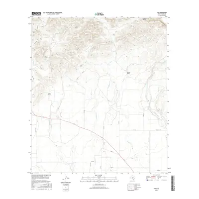
2016 Map of Trio
USGS Topo · Published 2016About this map
Trio serves as the focal point of this rural Uvalde County landscape, situated where several local routes converge amidst a network of Texas hill country drainages. The topography is defined by significant relief, featuring landmarks like Ringtail Mtn and the prominent Horseshoe Bend along Blanco Cr. This survey illustrates a settlement pattern of isolated ranches and homesteads connected by a complex system of county roads, including Folts Ranch Rd and Ten Mile Rd. The eastern portion of the map is dominated by the course of the Sabinal River, while numerous ephemeral and perennial streams such as Nolton Cr, Little Blanco Cr, and Dinner Cr carve out named canyons like Catclaw Hollow and Crane Hollow. Geologic features like Sinks Hill and the hydrologic importance of Reiner Springs suggest a landscape where water access and terrain dictated the placement of early ranching infrastructure.
Find a feature on this map
34 named features on this map. Tap any name to fly to it.
Don’t see what you’re looking for? This feature index may not catch every label — zoom into the map to look around manually.
Map Details
Editions of this 2016 Trio Map
This is the sole edition of this map. No revisions or reprints were ever made.
Other maps of this area

1898 · Uvalde
USGS Topo · 1:125,000

1899 · Uvalde
USGS Topo · 1:125,000

1954 · San Antonio
USGS Topo · 1:250,000

1956 · Sabinal
USGS Topo · 1:62,500

1956 · Tarpley
USGS Topo · 1:62,500

1956 · Utopia
USGS Topo · 1:62,500

1957 · San Antonio
USGS Topo · 1:250,000

1960 · Concan
USGS Topo · 1:24,000

1960 · Magers Crossing
USGS Topo · 1:24,000

1969 · Comanche Waterhole
USGS Topo · 1:24,000