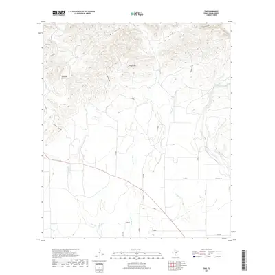
2019 Map of Trio
USGS Topo · Published 2019About this map
Ringtail Mtn and Sinks Hill dominate the northern terrain of this Uvalde County region, where the Edwards Plateau begins to break toward the southern plains. The drainage network is particularly defined, featuring the winding Sabinal River on the eastern edge and the converging paths of Blanco Cr and Little Blanco Cr. The landscape is etched by named canyons and depressions like Turkey Hollow and Catclaw Hollow, indicating a karst topography common to the Texas Hill Country. Reiner Springs provides a rare point of permanent water in a landscape of seasonal creeks and intermittent flows. Tracing the path of Ranch Rd 1049 and Farm Rd 30 reveals how modern transportation follows the natural contours of the land, navigating around the prominent Horseshoe Bend and through the various hollows that define the local geography.
Find a feature on this map
34 named features on this map. Tap any name to fly to it.
Don’t see what you’re looking for? This feature index may not catch every label — zoom into the map to look around manually.
Map Details
Editions of this 2019 Trio Map
This is the sole edition of this map. No revisions or reprints were ever made.
Other maps of this area

1898 · Uvalde
USGS Topo · 1:125,000

1899 · Uvalde
USGS Topo · 1:125,000

1954 · San Antonio
USGS Topo · 1:250,000

1956 · Sabinal
USGS Topo · 1:62,500

1956 · Tarpley
USGS Topo · 1:62,500

1956 · Utopia
USGS Topo · 1:62,500

1957 · San Antonio
USGS Topo · 1:250,000

1960 · Concan
USGS Topo · 1:24,000

1960 · Magers Crossing
USGS Topo · 1:24,000

1969 · Comanche Waterhole
USGS Topo · 1:24,000