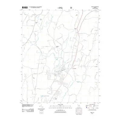
2011 Map of Trion
USGS Topo · Published 2011About this map
The Chattooga River defines the landscape of this northwest Georgia corridor, winding southward through Trion and East Trion. This survey documents a rural and industrial transition zone where the river valley is hemmed in by the high elevation of Taylor Ridge to the east. The settlement pattern is largely concentrated along the river and the parallel highway corridor, with outlying communities like Welcome Hill and Oakton serving as local nodes. For genealogists and local historians, the sheet is exceptionally detailed in its documentation of burial sites, including the Wesley Chapel Cemetery, Paynes Chapel Cemetery, and Algood Cemetery. Water management is evident through various features like the Lake Wanda Reita Dam and numerous small lakes such as Carp Lake and Sucker Lake, which punctuate the valley floor between the rolling hills and the river’s edge.
Find a feature on this map
96 named features on this map. Tap any name to fly to it.
Don’t see what you’re looking for? This feature index may not catch every label — zoom into the map to look around manually.
Map Details
Editions of this 2011 Trion Map
This is the sole edition of this map. No revisions or reprints were ever made.
Other maps of this area

1886 · Ringgold
USGS Topo · 1:125,000

1886 · Rome
USGS Topo · 1:125,000

1892 · Ringgold
USGS Topo · 1:125,000

1898 · Rome
USGS Topo · 1:125,000

1899 · Rome
USGS Topo · 1:125,000

1904 · Rome
USGS Topo · 1:125,000

1935 · Catlett
USGS Topo · 1:24,000

1936 · Estelle
USGS Topo · 1:24,000

1936 · Dougherty Gap
USGS Topo · 1:24,000
1936 · Cedar Grove
USGS Topo · 1:24,000