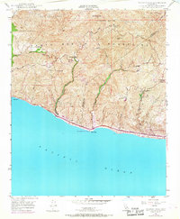
1949 Map of Triunfo Pass
USGS Topo · Published 1968About this map
The Santa Monica Mountains meet the coast in this topographic study, where deep ravines like Little Sycamore Canyon and Nicholas Canyon carve through the steep terrain of the Topanga Malibu Sequit. Human presence is concentrated along the shoreline and a few winding mountain routes, with the Roosevelt Highway tracing the edge of the Pacific Ocean past Solromar and Leo Carrillo State Beach. Education for the mountain communities is centered at the Yerba Buena Sch and Decker Sch, while fire protection is evidenced by the Triunfo Lookout and Lachusa Fire Patrol Sta. The map highlights the intersection of the Ventura and Los Angeles County line, crossing high points like Sandstone Pk and descending through Sequit Creek to Sequit Point. The 1967 photorevisions, shown in purple, reveal the gradual expansion of roads such as the Mulholland Highway into these previously remote coastal ridges.
Find a feature on this map
38 named features on this map. Tap any name to fly to it.
Don’t see what you’re looking for? This feature index may not catch every label — zoom into the map to look around manually.
Map Details
Editions of this 1949 Triunfo Pass Map
3 editions found
Other maps of this area

1900 · Triunfo Pass
USGS Topo · 1:62,500

1903 · Camulos
USGS Topo · 1:125,000

1904 · Hueneme
USGS Topo · 1:62,500

1921 · Triunfo Pass
USGS Topo · 1:62,500

1929 · Dume Point
USGS Topo · 1:24,000

1932 · Dume Point
USGS Topo · 1:24,000

1932 · Russell Valley
USGS Topo · 1:24,000

1932 · Arroyo Sequit
USGS Topo · 1:24,000

1942 · Hueneme
USGS Topo · 1:62,500

1943 · Hueneme
USGS Topo · 1:62,500
Featured Places
- Malibu, CA
- South Beach, CA
- Unincorporated Santa Monica Mountains, CA
- Ventura County, CA
- Los Angeles County, CA