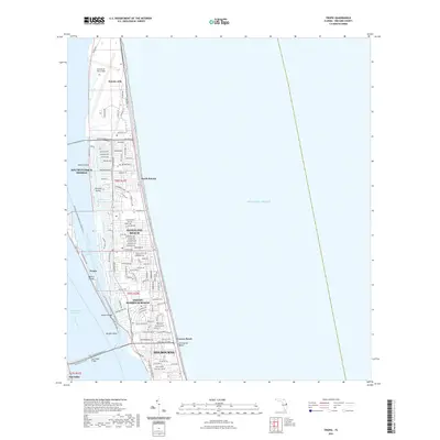
2021 Map of Tropic
USGS Topo · Published 2021About this map
Patrick Air Force Base dominates the northern barrier island landscape, a critical aerospace and military installation situated between the Banana River and the Atlantic Ocean. This 2021 survey details the dense suburban development of the Space Coast, where established beach communities like Satellite Beach and Indian Harbour Beach are tightly gridded against the shoreline. The map reveals the intricate water-bound geography of the area, featuring the winding Grand Canal through residential tracts and the isolated positions of Tortoise Island and Nesbit Island. Towards the southern extent, the map covers the coastal reaches of Melbourne and the historic Eau Gallie district. Regional connectivity is highlighted by the Pineda Cswy and Eau Gallie Cswy, linking the mainland to these developed keys and highlighting the area's modern evolution from its early maritime roots near Dragon Point.
Find a feature on this map
107 named features on this map. Tap any name to fly to it.
Don’t see what you’re looking for? This feature index may not catch every label — zoom into the map to look around manually.
Map Details
Editions of this 2021 Tropic Map
This is the sole edition of this map. No revisions or reprints were ever made.
Other maps of this area

1949 · Melbourne West
USGS Topo · 1:24,000

1949 · Melbourne East
USGS Topo · 1:24,000

1949 · Eau Gallie
USGS Topo · 1:24,000

1949 · Cocoa
USGS Topo · 1:24,000

1949 · Cocoa Beach
USGS Topo · 1:24,000

1949 · Tropic
USGS Topo · 1:24,000

1951 · Melbourne East
USGS Topo · 1:24,000

1951 · Eau Gallie
USGS Topo · 1:24,000

1951 · Cocoa
USGS Topo · 1:24,000

1951 · Melbourne West
USGS Topo · 1:24,000