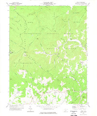
1977 Map of Trout
USGS Topo · Published 1978About this map
Monongahela National Forest dominates this Greenbrier County landscape, where the high ridges of the Yew Mountains and Cold Knob Ridge frame a series of small, isolated mountain communities. In the southern half of the quadrangle, human settlement clings to the drainage basins of Spring Creek and its tributaries, with the hamlets of Trout, Friars Hill, and Esty serving as local anchors. The map reveals the social infrastructure of the mid-1970s through several country churches, including New Ellis Chapel and the Band of Hope Ch, alongside family-named sites like Mc Million Cem. Industrial presence is noted in the northern reaches via Strip Mines near Blue Knob, while the timber and conservation heritage of the area is represented by the Lookout Tower on Grassy Knob and the defined Williamsburg National Forest Boundary.
Find a feature on this map
63 named features on this map. Tap any name to fly to it.
Don’t see what you’re looking for? This feature index may not catch every label — zoom into the map to look around manually.
Map Details
Editions of this 1977 Trout Map
3 editions found
Other maps of this area

1887 · Hinton
USGS Topo · 1:125,000

1887 · Lewisburg
USGS Topo · 1:125,000

1889 · Nicholas
USGS Topo · 1:125,000

1891 · Lewisburg
USGS Topo · 1:125,000

1891 · Nicholas
USGS Topo · 1:125,000

1891 · Huntersville
USGS Topo · 1:125,000

1892 · Hinton
USGS Topo · 1:125,000

1894 · Huntersville
USGS Topo · 1:125,000

1901 · Nicholas
USGS Topo · 1:125,000

1918 · Richwood
USGS Topo · 1:62,500