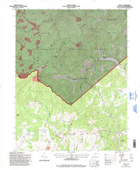
1995 Map of Trout
USGS Topo · Published 1998About this map
Monongahela National Forest dominates the northern half of this landscape, where the ridges of Knob Mountain and Big Ridge meet the headwaters of Spring Creek. Extensive strip mines are visible along the upper elevations near Blue Knob, indicating the industrial activity that shared this forest land in the late 20th century. To the south, the terrain transitions into the agricultural and rural church communities of Williamsburg, where small settlements like Trout and Friars Hill are connected by winding mountain roads.
Find a feature on this map
62 named features on this map. Tap any name to fly to it.
Don’t see what you’re looking for? This feature index may not catch every label — zoom into the map to look around manually.
Map Details
Editions of this 1995 Trout Map
This is the sole edition of this map. No revisions or reprints were ever made.
Other maps of this area

1887 · Hinton
USGS Topo · 1:125,000

1887 · Lewisburg
USGS Topo · 1:125,000

1889 · Nicholas
USGS Topo · 1:125,000

1891 · Lewisburg
USGS Topo · 1:125,000

1891 · Nicholas
USGS Topo · 1:125,000

1891 · Huntersville
USGS Topo · 1:125,000

1892 · Hinton
USGS Topo · 1:125,000

1894 · Huntersville
USGS Topo · 1:125,000

1901 · Nicholas
USGS Topo · 1:125,000

1918 · Richwood
USGS Topo · 1:62,500