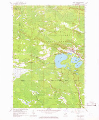
1964 Map of Trout Lake
USGS Topo · Published 1966About this map
The railroad junction of Trout Lake serves as the focal point for this mid-1960s survey of the Upper Peninsula, where the Soo Line tracks cut through a landscape of dense woods and glacial lakes. This remote pocket of the Hiawatha National Forest and Mackinac State Forest is defined by its water systems, notably Carp Lake and the branching headwaters of the Carp River. Local landmarks include School No 15 and Lakeview Cem, alongside smaller water bodies like Frenchman Lake and Wegwaas Lake. The presence of the Landing Strip and named logging routes such as Bobbygay Road reflects a wilderness economy balancing seasonal recreation at Trout Lake Park with the timber industry. The map captures the precise boundary between Chippewa and Mackinac Counties, illustrating how the town's grid provides a rare pocket of structure within the surrounding wetlands and timberlands.
Find a feature on this map
27 named features on this map. Tap any name to fly to it.
Don’t see what you’re looking for? This feature index may not catch every label — zoom into the map to look around manually.
Map Details
Editions of this 1964 Trout Lake Map
2 editions found
Other maps of this area

1931 · Epoufette SE
USGS Topo · 1:31,680

1931 · Epoufette NE
USGS Topo · 1:31,680

1931 · Epoufette NW
USGS Topo · 1:31,680

1931 · Epoufette SW
USGS Topo · 1:31,680

1941 · Strongs
USGS Topo · 1:63,360

1951 · Strongs
USGS Topo · 1:24,000

1951 · Hulbert
USGS Topo · 1:24,000

1951 · Eckerman
USGS Topo · 1:24,000

1951 · Strongs
USGS Topo · 1:62,500

1951 · Eckerman
USGS Topo · 1:62,500