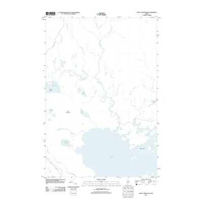
2011 Map of Trout Mountain
USGS Topo · Published 2011About this map
Millinocket Lake dominates the southern portion of this northern Maine landscape, its waters dotted by State Island and numerous smaller landforms. The terrain rises to the west at Trout Mountain, a prominent landmark overlooking a network of ponds including Oak Hill Pond, Bottle Pond, and the Twin Ponds. This area is characterized by an intricate drainage system where Togue Stream and Sandy Stream feed into the larger basins.
Find a feature on this map
21 named features on this map. Tap any name to fly to it.
Don’t see what you’re looking for? This feature index may not catch every label — zoom into the map to look around manually.
Map Details
Editions of this 2011 Trout Mountain Map
This is the sole edition of this map. No revisions or reprints were ever made.
Other maps of this area

1927 · Katahdin
USGS Topo · 1:48,000

1930 · Katahdin
USGS Topo · 1:62,500

1949 · Katahdin
USGS Topo · 1:62,500

1951 · Norcross
USGS Topo · 1:62,500

1951 · Millinocket
USGS Topo · 1:62,500

1953 · Stacyville
USGS Topo · 1:62,500

1954 · Millinocket
USGS Topo · 1:250,000

1958 · Millinocket
USGS Topo · 1:250,000

1960 · Millinocket
USGS Topo · 1:250,000
1975 · Stacyville NW
USGS Topo · 1:24,000