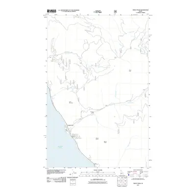
2011 Map of Trout Peak
USGS Topo · Published 2011About this map
Lake Pend Oreille defines the western edge of this landscape, where the settlement of Trestle Creek serves as a primary access point to the water and the rising mountains to the east. The terrain is marked by steep drainages and significant peaks, including Trout Peak, Mount Eagen, and Mount Marion. A network of Forest Service roads, such as Trestle Creek Rd and Trout Creek Rd, provides passage through the drainage basins of Glazier Creek and Cochran Creek. This 2011 survey captures the area's transition from the shoreline at the Trestle Creek Boat Ramp and Pringle Boat Launch to the high elevations of Grief Mountain. The detailed mapping of small waterways like Strong Creek and Shertz Creek illustrates the complex hydrology that feeds the lake from the Cabinet Mountains.
Find a feature on this map
30 named features on this map. Tap any name to fly to it.
Don’t see what you’re looking for? This feature index may not catch every label — zoom into the map to look around manually.
Map Details
Editions of this 2011 Trout Peak Map
This is the sole edition of this map. No revisions or reprints were ever made.
Other maps of this area

1911 · Priest Lake
USGS Topo · 1:250,000

1913 · Priest Lake
USGS Topo · 1:250,000

1949 · Packsaddle Mtn
USGS Topo · 1:62,500

1951 · Packsaddle Mtn
USGS Topo · 1:62,500

1951 · Clark Fork
USGS Topo · 1:62,500

1951 · Mt Pend Oreille
USGS Topo · 1:62,500

1951 · Elmira
USGS Topo · 1:62,500

1958 · Sandpoint
USGS Topo · 1:250,000

1963 · Sandpoint
USGS Topo · 1:250,000
1984 · Sandpoint
USGS Topo · 1:100,000