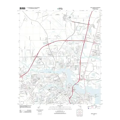
2012 Map of Trout River
USGS Topo · Published 2012About this map
Jacksonville International Airport occupies the northern reaches of this coastal Florida landscape, where suburban expansion meets the winding tributaries of the Trout River. This region is defined by its intricate water network, including the Ribault River and Broward River, which separate numerous residential neighborhoods such as Ribault Manor, Sherwood Forest, and Lake Forest Hills. A high concentration of memorial sites and cemeteries, including Restlawn Memorial Park and the Paupers Cem, provides significant detail for genealogical research in the Duval County area. Near the confluence of the Trout and Saint Johns River, landmarks like the Jacksonville Zoo and the City of Jacksonville Fireboat Pier mark the transition toward the city's industrial and maritime corridor. The map also captures the campus of Florida Community College - North Campus, illustrating the mid-century to modern-day growth of northern Jacksonville.
Find a feature on this map
55 named features on this map. Tap any name to fly to it.
Don’t see what you’re looking for? This feature index may not catch every label — zoom into the map to look around manually.
Map Details
Editions of this 2012 Trout River Map
This is the sole edition of this map. No revisions or reprints were ever made.
Other maps of this area

1917 · Cambon
USGS Topo · 1:62,500

1917 · Hilliard
USGS Topo · 1:62,500

1918 · St Marys
USGS Topo · 1:62,500

1918 · Cambon
USGS Topo · 1:62,500

1918 · Jacksonville
USGS Topo · 1:62,500

1919 · St Marys
USGS Topo · 1:62,500

1919 · Hilliard
USGS Topo · 1:62,500

1948 · Jacksonville
USGS Topo · 1:250,000

1948 · Eastport
USGS Topo · 1:24,000

1950 · Arlington
USGS Topo · 1:24,000
Featured Places
- Jacksonville, FL
- Biscayne Village, Jacksonville
- Dinsmore, Jacksonville
- Lake Forest Hills, Jacksonville
- Ribault Manor, Jacksonville