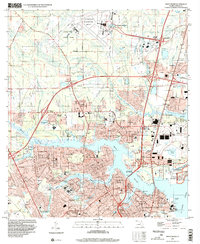
1994 Map of Trout River
USGS Topo · Published 2002About this map
Jacksonville International Airport and the State Air National Guard installations define the northern reaches of this Duval County landscape in the mid-1990s. The map illustrates a dense residential and suburban expansion south of the Base Line, where established neighborhoods like Sherwood Forest and Ribault Manor sit alongside the winding path of the Trout River. The southern portion is characterized by a concentrated network of civic and religious institutions, including the Duval County Paupers Cem and Pinehurst Cem, alongside numerous educational facilities such as Ribault High Sch. The riverine geography is central to the area's layout, with the Ribault River and Moncrief Creek threading through communities toward the St Johns River. Strategic infrastructure is also visible, from the US Naval Fuel Depot to the Seaboard System rail lines that support the region's industrial and military presence.
Find a feature on this map
81 named features on this map. Tap any name to fly to it.
Don’t see what you’re looking for? This feature index may not catch every label — zoom into the map to look around manually.
Map Details
Editions of this 1994 Trout River Map
This is the sole edition of this map. No revisions or reprints were ever made.
Other maps of this area

1917 · Cambon
USGS Topo · 1:62,500

1917 · Hilliard
USGS Topo · 1:62,500

1918 · St Marys
USGS Topo · 1:62,500

1918 · Cambon
USGS Topo · 1:62,500

1918 · Jacksonville
USGS Topo · 1:62,500

1919 · St Marys
USGS Topo · 1:62,500

1919 · Hilliard
USGS Topo · 1:62,500

1948 · Jacksonville
USGS Topo · 1:250,000

1948 · Eastport
USGS Topo · 1:24,000

1950 · Arlington
USGS Topo · 1:24,000
Featured Places
- Jacksonville, FL
- Lake Park Estates, Jacksonville
- Lake Forest Manor, Jacksonville
- Garden City, Jacksonville
- Oakhurst, Jacksonville