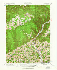
1921 Map of Trout Run
USGS Topo · Published 1964About this map
Lycoming Creek serves as the primary corridor for the Pennsylvania RR as it cuts through the high plateaus and deep hollows north of Williamsport. This 1921 survey illustrates a rural economy transitioning from timber to localized agriculture, evidenced by the dense network of small schoolhouses and family-named ridges. Notable industrial vestiges like Nail Factory Mtn and Falls Factory School near Hepburnville hint at the manufacturing history that once dotted these creek valleys.
Find a feature on this map
118 named features on this map. Tap any name to fly to it.
Don’t see what you’re looking for? This feature index may not catch every label — zoom into the map to look around manually.
Map Details
Editions of this 1921 Trout Run Map
Other maps of this area

1921 · Williamsport
USGS Topo · 1:48,000

1921 · Trout Run
USGS Topo · 1:62,500

1921 · Lock Haven
USGS Topo · 1:62,500

1923 · Lock Haven
USGS Topo · 1:62,500

1923 · Trout Run
USGS Topo · 1:62,500

1923 · Williamsport
USGS Topo · 1:62,500

1924 · Milton
USGS Topo · 1:62,500

1925 · Blossburg
USGS Topo · 1:62,500

1927 · Blossburg
USGS Topo · 1:62,500

1930 · Warrensville
USGS Topo · 1:62,500
Featured Places
- Williamsport, PA
- Garden View, Old Lycoming Township
- Salladasburg, PA
- Woodward Township, PA
- Steam Valley, Cogan House Township