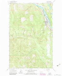
1983 Map of Troy
USGS Topo · Published 1984About this map
The town of Troy sits along a bend in the Kootenai River, serving as a vital hub where the Burlington Northern railroad meets the rugged mountains of the Kootenai National Forest. This 1980s revision reflects a landscape shaped by both timber and mineral extraction, with the valley floor supporting a Landing Strip and an Athletic Field while the surrounding peaks are honeycombed with legacy mining operations.
Find a feature on this map
42 named features on this map. Tap any name to fly to it.
Don’t see what you’re looking for? This feature index may not catch every label — zoom into the map to look around manually.
Map Details
Editions of this 1983 Troy Map
This is the sole edition of this map. No revisions or reprints were ever made.
Other maps of this area

1911 · Priest Lake
USGS Topo · 1:250,000

1913 · Priest Lake
USGS Topo · 1:250,000

1920 · Libby
USGS Topo · 1:125,000

1930 · Libby
USGS Topo · 1:125,000

1932 · Libby
USGS Topo · 1:125,000

1951 · Mt Pend Oreille
USGS Topo · 1:62,500

1957 · Kalispell
USGS Topo · 1:250,000

1958 · Sandpoint
USGS Topo · 1:250,000

1960 · Kalispell
USGS Topo · 1:250,000

1961 · Kalispell
USGS Topo · 1:250,000