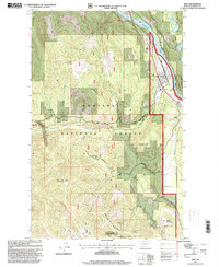
1997 Map of Troy
USGS Topo · Published 2000About this map
Troy sits at the confluence of the Kootenai River and Callahan Creek, serving as a vital hub for the extraction and transport industries of northwest Montana. The town center is defined by its rail connection to the Burlington Northern line and local landmarks like the Water Tank and Athletic Field. To the south and west, the terrain rises into the Kootenai National Forest, where a significant mining legacy is etched into the mountain slopes. The landscape is dotted with workings such as the Snowstorm Mine and the Montana-Morning Mine, alongside several sites on Grouse Mountain, including the Giant Sunrise Mine and Silver Grouse Mine. These features represent a period of intensive geological exploration and industrial activity. Water resources are plentiful throughout the quadrangle, from the larger Kootenai River and Scott Island to smaller high-altitude water bodies like Alvord Lake and Slee Lake.
Find a feature on this map
37 named features on this map. Tap any name to fly to it.
Don’t see what you’re looking for? This feature index may not catch every label — zoom into the map to look around manually.
Map Details
Editions of this 1997 Troy Map
This is the sole edition of this map. No revisions or reprints were ever made.
Other maps of this area

1911 · Priest Lake
USGS Topo · 1:250,000

1913 · Priest Lake
USGS Topo · 1:250,000

1920 · Libby
USGS Topo · 1:125,000

1930 · Libby
USGS Topo · 1:125,000

1932 · Libby
USGS Topo · 1:125,000

1951 · Mt Pend Oreille
USGS Topo · 1:62,500

1957 · Kalispell
USGS Topo · 1:250,000

1958 · Sandpoint
USGS Topo · 1:250,000

1960 · Kalispell
USGS Topo · 1:250,000

1961 · Kalispell
USGS Topo · 1:250,000