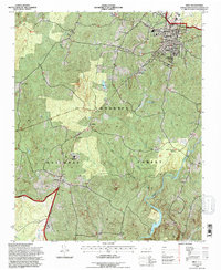
1994 Map of Troy
USGS Topo · Published 1996About this map
Troy serves as the regional hub in this 1994 snapshot of central North Carolina, situated where the Southern Railway and Norfolk Southern Railroad meet among the wooded hills. Much of the western landscape is dominated by the Uwharrie National Forest, a terrain of ridges and creeks like Toms Creek and Rocky Creek. The map documents a rural network of small communities and family landmarks, including Wadeville and Roberdo, alongside several country churches such as Mt Carmel Ch and Ropers Grove Ch. Local heritage is well-preserved through numerous marked burial sites like Chisholm Cem and the McRae Cem. The presence of the West Montgomery High Sch and landmarks like Yates Place provide a detailed look at the social and physical infrastructure of Montgomery County during the mid-1990s.
Find a feature on this map
56 named features on this map. Tap any name to fly to it.
Don’t see what you’re looking for? This feature index may not catch every label — zoom into the map to look around manually.
Map Details
Editions of this 1994 Troy Map
This is the sole edition of this map. No revisions or reprints were ever made.
Other maps of this area

1942 · Troy
USGS Topo · 1:125,000

1953 · Raleigh
USGS Topo · 1:250,000

1953 · Charlotte
USGS Topo · 1:250,000

1954 · Charlotte
USGS Topo · 1:250,000

1954 · Raleigh
USGS Topo · 1:250,000

1956 · Mount Gilead East
USGS Topo · 1:24,000

1956 · Harrisville
USGS Topo · 1:24,000

1956 · Mount Gilead West
USGS Topo · 1:24,000

1957 · Albemarle
USGS Topo · 1:62,500

1957 · Troy
USGS Topo · 1:62,500