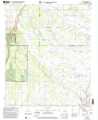
2000 Map of Troy SE
USGS Topo · Published 2002About this map
Okolona anchors the southeastern corner of this Chickasaw County landscape, serving as a gateway to a region defined by its numerous rural congregations and the winding path of the Natchez Trace Parkway. The topography is shaped by an intricate network of waterways, including Tallabinnela Creek and Tubbalubba Creek, which drain the low-lying areas between small agricultural communities. This 2000 revision, updated by the Forest Service, highlights the boundaries of the Tombigbee National Forest and the Scenic Parkway corridor.
Find a feature on this map
36 named features on this map. Tap any name to fly to it.
Don’t see what you’re looking for? This feature index may not catch every label — zoom into the map to look around manually.
Map Details
Editions of this 2000 Troy SE Map
This is the sole edition of this map. No revisions or reprints were ever made.
Other maps of this area

1953 · West Point
USGS Topo · 1:250,000

1956 · Tupelo
USGS Topo · 1:250,000

1958 · Tupelo
USGS Topo · 1:250,000

1958 · West Point
USGS Topo · 1:250,000

1959 · Van Vleet
USGS Topo · 1:62,500

1963 · West Point
USGS Topo · 1:250,000

1965 · Egypt
USGS Topo · 1:24,000

1966 · Shannon
USGS Topo · 1:24,000

1966 · Troy NW
USGS Topo · 1:24,000

1966 · Troy SE
USGS Topo · 1:24,000