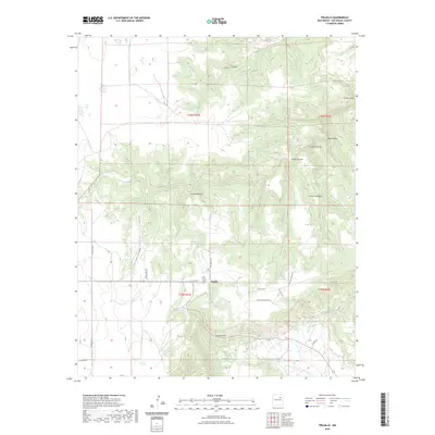
2023 Map of Trujillo
USGS Topo · Published 2023About this map
The settlement of Trujillo serves as the focal point for this section of San Miguel County, situated along the northern banks of Corazon Creek. This 2023 survey illustrates the enduring rural character of the landscape, where local life centers on the junction of several county routes including Co RD c51a and the Camino De Gutierrez. For genealogists, the San Isidro Cem provides a specific point of historical interest near the town center. To the north, the terrain becomes deeply carved by a series of dramatic canyons, most notably Cañon Ventanas, Cañon Santiago, and Cañon Largo. These drainage patterns, including Cañon Ciruela, define the high mesas and difficult topography of the region. The map also records localized place names such as Corazon Hill and the Pedro Romero LM, reflecting the deep-seated family history and ranching heritage found throughout this New Mexican highland.
Find a feature on this map
26 named features on this map. Tap any name to fly to it.
Don’t see what you’re looking for? This feature index may not catch every label — zoom into the map to look around manually.
Map Details
Editions of this 2023 Trujillo Map
This is the sole edition of this map. No revisions or reprints were ever made.
Other maps of this area

1892 · Watrous
USGS Topo · 1:125,000

1892 · Corazon
USGS Topo · 1:125,000

1894 · Corazon
USGS Topo · 1:125,000

1894 · Watrous
USGS Topo · 1:125,000

1954 · Santa Fe
USGS Topo · 1:250,000

1958 · Santa Fe
USGS Topo · 1:250,000

1963 · Flagstone Mountain
USGS Topo · 1:24,000

1971 · Laguna Huerfana
USGS Topo · 1:24,000
1971 · Canon Pedroso
USGS Topo · 1:24,000

1971 · Trujillo
USGS Topo · 1:24,000