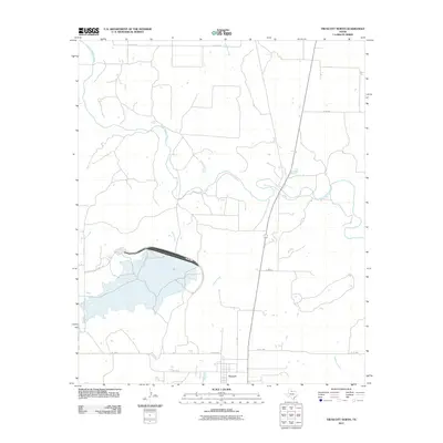
2011 Map of Truscott North
USGS Topo · Published 2011About this map
Truscott sits at the southern edge of this north-central Texas landscape, serving as the primary hub for a network of rural roads such as Co RD 2600 and Co RD 2605. The terrain is defined by the winding course of the North Wichita River, which meanders through the central portion of the quadrangle. This water system is supported by numerous named tributaries, including Salt Flat Creek and Bluff Creek, creating a highly dissected landscape characteristic of the region's drainage patterns.
Find a feature on this map
22 named features on this map. Tap any name to fly to it.
Don’t see what you’re looking for? This feature index may not catch every label — zoom into the map to look around manually.
Map Details
Editions of this 2011 Truscott North Map
This is the sole edition of this map. No revisions or reprints were ever made.
Other maps of this area

1954 · Wichita Falls
USGS Topo · 1:250,000

1958 · Wichita Falls
USGS Topo · 1:250,000

1966 · Truscott North
USGS Topo · 1:24,000

1966 · Truscott South
USGS Topo · 1:24,000

1966 · Halsell Ranch
USGS Topo · 1:24,000

1966 · Gilliland
USGS Topo · 1:24,000

1966 · Big Four Ranch
USGS Topo · 1:24,000

1966 · Crowell
USGS Topo · 1:24,000

1966 · Maverick Flat
USGS Topo · 1:24,000
1968 · Boiling Spring
USGS Topo · 1:24,000