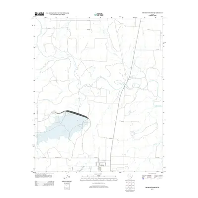
2013 Map of Truscott North
USGS Topo · Published 2013About this map
Truscott Brine Lake dominates the central-western portion of this North Texas landscape, a major hydrological feature within the drainage basin of the N Wichita River. The map captures the area around the small settlement of Truscott, where local street names like N Floyd Ave and S Pecos Ave intersect with the rural road network. The terrain is defined by a dense network of seasonal and permanent watercourses, including China Cr, Salt Flat Cr, and Deadman Cr, which carve through the plains. Ranching and land management are evident through named corridors such as Daniels Ranch Rd and Ranch Road 1756. This 2013 survey documents the intersection of modern infrastructure with the traditional water-dependent geography of Knox County, showcasing the specific footprints of local thoroughfares and the expansive brine management system.
Find a feature on this map
34 named features on this map. Tap any name to fly to it.
Don’t see what you’re looking for? This feature index may not catch every label — zoom into the map to look around manually.
Map Details
Editions of this 2013 Truscott North Map
This is the sole edition of this map. No revisions or reprints were ever made.
Other maps of this area

1954 · Wichita Falls
USGS Topo · 1:250,000

1958 · Wichita Falls
USGS Topo · 1:250,000

1966 · Truscott North
USGS Topo · 1:24,000

1966 · Truscott South
USGS Topo · 1:24,000

1966 · Halsell Ranch
USGS Topo · 1:24,000

1966 · Gilliland
USGS Topo · 1:24,000

1966 · Big Four Ranch
USGS Topo · 1:24,000

1966 · Crowell
USGS Topo · 1:24,000

1966 · Maverick Flat
USGS Topo · 1:24,000
1968 · Boiling Spring
USGS Topo · 1:24,000