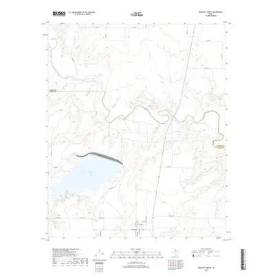
2019 Map of Truscott North
USGS Topo · Published 2019About this map
Truscott sits near the southern edge of this West Texas landscape, positioned at a local crossroads marked by N Hill Ave and S Hill Ave. The geography is defined by the winding course of the North Wichita River, which carves a deep path across the northern half of the territory, joined by numerous seasonal drainages including Black Top Cr and Buffalo Cr. A significant modern hydrological feature, the Truscott Brine Lake, dominates the central-west portion of the map, held by a large dam structure. This specialized reservoir, part of regional salinity control efforts, contrasts with the natural riparian corridors of Salt Flat Cr and China Cr. The area is interlaced with a grid of county roads such as Co Rd 2631 and Co Rd 3600, facilitating access to the agricultural lands spanning the Foard and Knox county line.
Find a feature on this map
34 named features on this map. Tap any name to fly to it.
Don’t see what you’re looking for? This feature index may not catch every label — zoom into the map to look around manually.
Map Details
Editions of this 2019 Truscott North Map
This is the sole edition of this map. No revisions or reprints were ever made.
Other maps of this area

1954 · Wichita Falls
USGS Topo · 1:250,000

1958 · Wichita Falls
USGS Topo · 1:250,000

1966 · Truscott North
USGS Topo · 1:24,000

1966 · Truscott South
USGS Topo · 1:24,000

1966 · Halsell Ranch
USGS Topo · 1:24,000

1966 · Gilliland
USGS Topo · 1:24,000

1966 · Big Four Ranch
USGS Topo · 1:24,000

1966 · Crowell
USGS Topo · 1:24,000

1966 · Maverick Flat
USGS Topo · 1:24,000
1968 · Boiling Spring
USGS Topo · 1:24,000