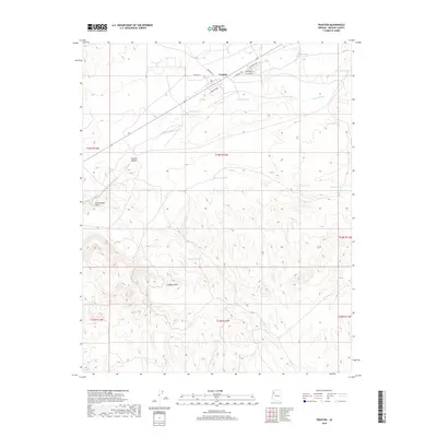
2018 Map of Truxton
USGS Topo · Published 2018About this map
Truxton anchors this High Desert landscape, situated along a transportation corridor defined by several local thoroughfares including Sunset Strip and Lincoln St. The settlement's placement at the convergence of Truxton Wash and Truxton Canyon highlights the historical importance of natural drainage routes for early desert infrastructure. Beyond the small grid of streets like Apache Ave and Cherokee Ave, the terrain rises toward the western edge of the quadrangle at the Cottonwood Cliffs. This arid environment is marked by numerous water management features essential for ranching and survival, such as Walkover Tank, Dead Cow Tank, and Mud Tank. The map also traces the winding paths of Cherokee Wash and Hidden Wash, which slice through the township lines of T24N and T23N, illustrating how topographic relief dictated land use in northern Arizona.
Find a feature on this map
25 named features on this map. Tap any name to fly to it.
Don’t see what you’re looking for? This feature index may not catch every label — zoom into the map to look around manually.
Map Details
Editions of this 2018 Truxton Map
This is the sole edition of this map. No revisions or reprints were ever made.
Other maps of this area

1886 · Diamond Creek
USGS Topo · 1:250,000

1892 · Diamond Creek
USGS Topo · 1:250,000

1948 · Williams
USGS Topo · 1:250,000

1954 · Williams
USGS Topo · 1:250,000

1956 · Williams
USGS Topo · 1:250,000

1960 · Williams
USGS Topo · 1:250,000

1961 · Williams
USGS Topo · 1:250,000
1967 · Milkweed Canyon SE
USGS Topo · 1:24,000

1967 · Milkweed Canyon SW
USGS Topo · 1:24,000

1967 · Peach Springs
USGS Topo · 1:24,000