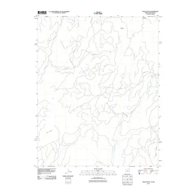
2010 Map of Tsaile Butte
USGS Topo · Published 2010About this map
Tunitcha Mountains and Chuska Mountains converge in this high-elevation landscape of the Shiprock Agency. The topographic detail highlights the dramatic rise of Tsaile Butte above the surrounding terrain, a prominent landmark that orients the drainage patterns of Tsaile Creek to the northwest. This 2010 survey records the presence of the Bee Sho Shee Mine in the northern reaches, reflecting the resource extraction history common in the region.
Find a feature on this map
14 named features on this map. Tap any name to fly to it.
Don’t see what you’re looking for? This feature index may not catch every label — zoom into the map to look around manually.
Map Details
Editions of this 2010 Tsaile Butte Map
This is the sole edition of this map. No revisions or reprints were ever made.
Other maps of this area

1889 · Chaco
USGS Topo · 1:250,000

1892 · Chaco
USGS Topo · 1:250,000

1892 · Canyon De Chelly
USGS Topo · 1:250,000

1953 · Sanostee
USGS Topo · 1:62,500

1954 · Shiprock
USGS Topo · 1:250,000
1955 · Sonsala Butte 1 NW
USGS Topo · 1:24,000

1955 · Sonsala Butte 4 NW
USGS Topo · 1:24,000

1955 · Sonsala Butte 1 SE
USGS Topo · 1:24,000
1955 · Sonsala Butte 1 NE
USGS Topo · 1:24,000

1955 · Sonsala Butte 1 SW
USGS Topo · 1:24,000