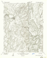
1955 Map of Sonsala Butte 1 NE
USGS Topo · Published 1958About this map
Roof Butte serves as a prominent high point in this mid-century survey of the Tunitcha Mountains, situated within the high-elevation landscape of the Navajo Indian Reservation. This map captures the rugged borderlands where Arizona and New Mexico meet, specifically looking at the intersection of Apache and San Juan Counties. The geography is defined by significant vertical relief, with seasonal drainages such as Red Wash and Pena Blanka Creek carving through the high plateau. High-altitude hydrology is marked by several clusters of Ponds and isolated Spring locations. To the east, the steep slopes of Beautiful Mountain dominate the horizon. A lone Lookout positioned atop the butte suggests the area's importance for early fire detection or observation across this expansive terrain before the completion of more modern regional mapping projects.
Find a feature on this map
14 named features on this map. Tap any name to fly to it.
Don’t see what you’re looking for? This feature index may not catch every label — zoom into the map to look around manually.
Map Details
Editions of this 1955 Sonsala Butte 1 NE Map
This is the sole edition of this map. No revisions or reprints were ever made.
Other maps of this area

1889 · Chaco
USGS Topo · 1:250,000

1892 · Chaco
USGS Topo · 1:250,000

1892 · Canyon De Chelly
USGS Topo · 1:250,000

1934 · Ship Rock
USGS Topo · 1:62,500

1937 · Ship Rock
USGS Topo · 1:62,500

1953 · Sanostee
USGS Topo · 1:62,500

1953 · Redrock Valley SE
USGS Topo · 1:24,000

1953 · Redrock Valley SW
USGS Topo · 1:24,000

1953 · Redrock Valley
USGS Topo · 1:62,500

1954 · Shiprock
USGS Topo · 1:250,000