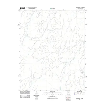
2011 Map of Tsaile Butte
USGS Topo · Published 2011About this map
Tsaile Butte and the high elevations of the Tunitcha Mountains define this high-altitude landscape on the Arizona-New Mexico border. The topography is shaped by a complex network of drainages, most notably Tsaile Creek in the northwest and Wheatfields Creek winding through the south and east. A collection of tribal and local routes, such as Indian Rte 30 and Beaver Creek Rd, provides the primary access through this remote territory. The presence of Hidden Valley tucked between mountain ridges suggests a secluded geographical pocket within the larger mountain range. This 2011 survey illustrates the modern road network and water management features of the region, emphasizing the sparse but vital infrastructure connecting these prominent geologic formations.
Find a feature on this map
10 named features on this map. Tap any name to fly to it.
Don’t see what you’re looking for? This feature index may not catch every label — zoom into the map to look around manually.
Map Details
Editions of this 2011 Tsaile Butte Map
This is the sole edition of this map. No revisions or reprints were ever made.
Other maps of this area

1889 · Chaco
USGS Topo · 1:250,000

1892 · Chaco
USGS Topo · 1:250,000

1892 · Canyon De Chelly
USGS Topo · 1:250,000

1953 · Sanostee
USGS Topo · 1:62,500

1954 · Shiprock
USGS Topo · 1:250,000
1955 · Sonsala Butte 1 NW
USGS Topo · 1:24,000

1955 · Sonsala Butte 4 NW
USGS Topo · 1:24,000

1955 · Sonsala Butte 1 SE
USGS Topo · 1:24,000
1955 · Sonsala Butte 1 NE
USGS Topo · 1:24,000

1955 · Sonsala Butte 1 SW
USGS Topo · 1:24,000