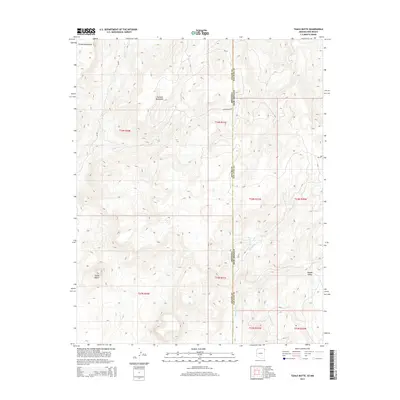
2014 Map of Tsaile Butte
USGS Topo · Published 2014About this map
The Tunitcha Mountains and the northern reaches of the Chuska Mountains dominate this high-elevation landscape along the border of Arizona and New Mexico. This 2014 survey captures a section of the Navajo Nation where the high desert meets forested peaks, marked by the prominent volcanic landform of Tsaile Butte. Water is a defining element of the geography here, with Tsaile Cr and Wheatfields Cr carving through the drainage basins of the Shiprock Agency. The map detail highlights the intersection of Apache County and San Juan County, illustrating the sparse network of tribal routes including Bia-68 and Gap Springs Rd that navigate the slopes and the secluded Hidden Valley. This modern USGS data offers a precise look at the topography and public land survey system divisions that define this remote corner of the Four Corners region.
Find a feature on this map
19 named features on this map. Tap any name to fly to it.
Don’t see what you’re looking for? This feature index may not catch every label — zoom into the map to look around manually.
Map Details
Editions of this 2014 Tsaile Butte Map
This is the sole edition of this map. No revisions or reprints were ever made.
Other maps of this area

1889 · Chaco
USGS Topo · 1:250,000

1892 · Chaco
USGS Topo · 1:250,000

1892 · Canyon De Chelly
USGS Topo · 1:250,000

1953 · Sanostee
USGS Topo · 1:62,500

1954 · Shiprock
USGS Topo · 1:250,000
1955 · Sonsala Butte 1 NW
USGS Topo · 1:24,000

1955 · Sonsala Butte 4 NW
USGS Topo · 1:24,000

1955 · Sonsala Butte 1 SE
USGS Topo · 1:24,000
1955 · Sonsala Butte 1 NE
USGS Topo · 1:24,000

1955 · Sonsala Butte 1 SW
USGS Topo · 1:24,000