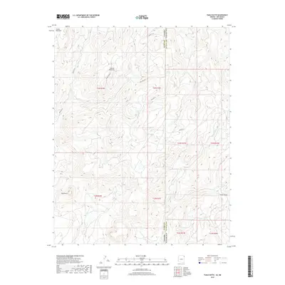
2018 Map of Tsaile Butte
USGS Topo · Published 2018About this map
Tsaile Butte dominates the southwestern quadrant of this high-altitude landscape, marking a prominent geological point within the Navajo Nation. The map captures the complex topography where the Tunitcha Mountains and Chuska Mountains converge along the border of Apache County, Arizona, and San Juan County, New Mexico. Drainage patterns are defined by Tsaile Cr and Wheatfields Cr, which carve through the elevated terrain and secluded pockets like Hidden Valley. Transportation across this remote area is facilitated by a network of regional corridors including Indian Rte 30, Indian Rte 68, and several unpaved routes such as Beaver Creek Rd and Gap Springs Rd. This survey reflects the modern management of tribal lands, illustrating the relationship between natural mountain barriers and the critical infrastructure that connects these high-desert communities.
Find a feature on this map
20 named features on this map. Tap any name to fly to it.
Don’t see what you’re looking for? This feature index may not catch every label — zoom into the map to look around manually.
Map Details
Editions of this 2018 Tsaile Butte Map
This is the sole edition of this map. No revisions or reprints were ever made.
Other maps of this area

1889 · Chaco
USGS Topo · 1:250,000

1892 · Chaco
USGS Topo · 1:250,000

1892 · Canyon De Chelly
USGS Topo · 1:250,000

1953 · Sanostee
USGS Topo · 1:62,500

1954 · Shiprock
USGS Topo · 1:250,000
1955 · Sonsala Butte 1 NW
USGS Topo · 1:24,000

1955 · Sonsala Butte 4 NW
USGS Topo · 1:24,000

1955 · Sonsala Butte 1 SE
USGS Topo · 1:24,000
1955 · Sonsala Butte 1 NE
USGS Topo · 1:24,000

1955 · Sonsala Butte 1 SW
USGS Topo · 1:24,000