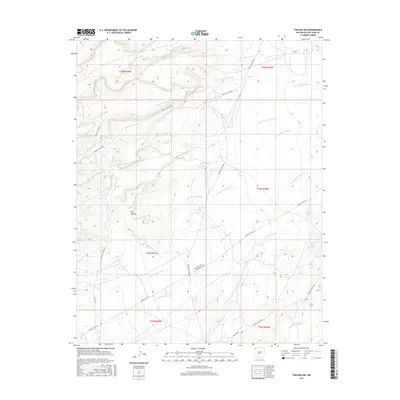
2017 Map of Tsin-nas-kid
USGS Topo · Published 2017About this map
The high desert landscape of northwestern New Mexico is defined here by an intricate network of drainages and seasonal watercourses. Tsin-nas-kid serves as a focal point in a terrain marked by deep washes, including the prominent To-nil-choni Wash and To-bil-hask-idi Wash. The convergence of these natural features illustrates the complex hydrology of the region, where water management is visible through the 12T-576 Water Well and the Captain Tom Reservoir in the southeast corner. Transport through this San Juan County territory relies on a system of Indian Service Routes, such as Indian Svc Rte 19 and Indian Svc Rte 5000, which navigate the contours between significant landmarks like Has-bi-di-to Wash and Tse-yaa-tohi Wash. This detailed topography offers a precise view of the land as it was documented in the mid-2010s, showing the relationship between modern infrastructure and ancient natural water paths.
Find a feature on this map
24 named features on this map. Tap any name to fly to it.
Don’t see what you’re looking for? This feature index may not catch every label — zoom into the map to look around manually.
Map Details
Editions of this 2017 Tsin-nas-kid Map
This is the sole edition of this map. No revisions or reprints were ever made.
Other maps of this area

1889 · Chaco
USGS Topo · 1:250,000

1892 · Chaco
USGS Topo · 1:250,000

1927 · Sulphur Spring
USGS Topo · 1:96,000

1928 · Kirtland
USGS Topo · 1:125,000

1932 · Kirtland
USGS Topo · 1:125,000

1953 · Sanostee
USGS Topo · 1:62,500

1954 · Shiprock
USGS Topo · 1:250,000

1958 · Shiprock
USGS Topo · 1:250,000

1959 · Shiprock
USGS Topo · 1:250,000
1966 · Sheep Springs
USGS Topo · 1:24,000