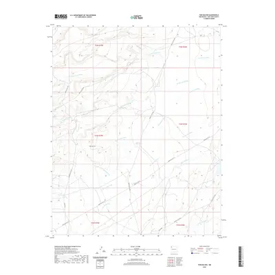
2020 Map of Tsin-nas-kid
USGS Topo · Published 2020About this map
The settlement of Tsin-nas-kid anchors this desert landscape in San Juan County, defined by an intricate network of seasonal drainages that pattern the high terrain. The geography is dominated by numerous named washes, such as To-nil-choni Wash in the north and Captain Tom Wash in the southeast, reflecting the vital importance of water pathways in this arid environment. Infrastructure in this area of the Shiprock Agency is primarily composed of tribal service roads, including Indian Svc Rte 19 and Indian Svc Rte 5000, which connect the scattered points of human presence. A singular recorded water source, the 12T-576 Water Well, serves as a critical landmark for local resources. The map details the complex topography where Leh-tso-bii-to Wash and Tse-nas-chii Wash converge, illustrating the natural land divisions and traditional travel routes through the region.
Find a feature on this map
22 named features on this map. Tap any name to fly to it.
Don’t see what you’re looking for? This feature index may not catch every label — zoom into the map to look around manually.
Map Details
Editions of this 2020 Tsin-nas-kid Map
This is the sole edition of this map. No revisions or reprints were ever made.
Other maps of this area

1889 · Chaco
USGS Topo · 1:250,000

1892 · Chaco
USGS Topo · 1:250,000

1927 · Sulphur Spring
USGS Topo · 1:96,000

1928 · Kirtland
USGS Topo · 1:125,000

1932 · Kirtland
USGS Topo · 1:125,000

1953 · Sanostee
USGS Topo · 1:62,500

1954 · Shiprock
USGS Topo · 1:250,000

1958 · Shiprock
USGS Topo · 1:250,000

1959 · Shiprock
USGS Topo · 1:250,000
1966 · Sheep Springs
USGS Topo · 1:24,000