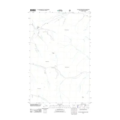
2011 Map of Tuchuck Mountain
USGS Topo · Published 2011About this map
Weasel Cabin stands as a lonely human outpost in this high-altitude landscape where the northern Rocky Mountains meet the Canadian border. The terrain is defined by a series of prominent peaks and basins, including Tuchuck Mountain, Review Mountain, and the broad Copeland Basin. This 2011 survey documents a complex network of drainage systems such as Nokio Creek and Yakinikak Creek, which carve through the high country. The map's detail provides a record of the remote forest road system, specifically the Natl Forest Develop Road 114 RD, which provides access to secluded areas like Timothy Meadow. These high meadows and mountain passes, such as Seemo Pass, represent a wild frontier character maintained well into the 21st century along the Montana-British Columbia boundary.
Find a feature on this map
26 named features on this map. Tap any name to fly to it.
Don’t see what you’re looking for? This feature index may not catch every label — zoom into the map to look around manually.
Map Details
Editions of this 2011 Tuchuck Mountain Map
This is the sole edition of this map. No revisions or reprints were ever made.
Other maps of this area

1913 · Stryker
USGS Topo · 1:125,000

1916 · Stryker
USGS Topo · 1:125,000

1957 · Kalispell
USGS Topo · 1:250,000

1960 · Kalispell
USGS Topo · 1:250,000

1961 · Kalispell
USGS Topo · 1:250,000

1963 · Mount Marston
USGS Topo · 1:24,000

1963 · Stahl Peak
USGS Topo · 1:24,000

1966 · Red Meadow Lake
USGS Topo · 1:24,000

1966 · Mount Hefty
USGS Topo · 1:24,000
1966 · Mount Thompson-Seton
USGS Topo · 1:24,000