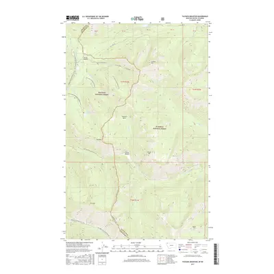
2017 Map of Tuchuck Mountain
USGS Topo · Published 2017About this map
Whitefish Divide serves as the prominent boundary between Lincoln and Flathead counties in this high-altitude landscape. The terrain is defined by a series of significant peaks including Tuchuck Mtn, Bald Mtn, Review Mtn, and Mt Lewis, which separate several drainage basins. High meadows such as Weasel Meadow and Timothy Meadow provide open spaces amidst the forested slopes of the Kootenai National Forest and Flathead National Forest. The hydrography of the region is equally complex, featuring Frozen Lake near the northern border and Weasel Lake to the west, with numerous watercourses like Otter Creek, Yakinikak Cr, and Snowshoe Cr carving through the valleys. For those tracing historical or recreational routes, the map details the Pacific NW National Scenic Trail as it winds through the southwestern corner, alongside several National Forest Development Roads and the Trail Creek RD in the north.
Find a feature on this map
40 named features on this map. Tap any name to fly to it.
Don’t see what you’re looking for? This feature index may not catch every label — zoom into the map to look around manually.
Map Details
Editions of this 2017 Tuchuck Mountain Map
This is the sole edition of this map. No revisions or reprints were ever made.
Other maps of this area

1913 · Stryker
USGS Topo · 1:125,000

1916 · Stryker
USGS Topo · 1:125,000

1957 · Kalispell
USGS Topo · 1:250,000

1960 · Kalispell
USGS Topo · 1:250,000

1961 · Kalispell
USGS Topo · 1:250,000

1963 · Mount Marston
USGS Topo · 1:24,000

1963 · Stahl Peak
USGS Topo · 1:24,000

1966 · Red Meadow Lake
USGS Topo · 1:24,000

1966 · Mount Hefty
USGS Topo · 1:24,000
1966 · Mount Thompson-Seton
USGS Topo · 1:24,000