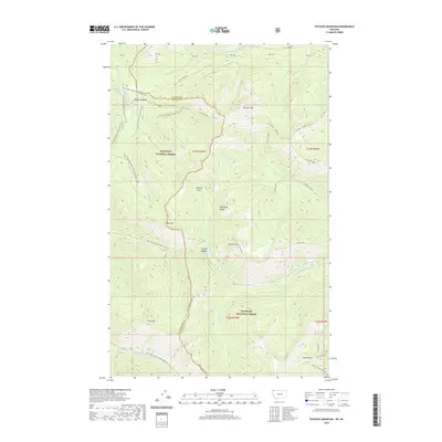
2020 Map of Tuchuck Mountain
USGS Topo · Published 2020About this map
The Whitefish Range dominates this corner of the Rockies along the border of Kootenai National Forest and Flathead National Forest. This 2020 map documents the complex hydrological and topographic divide where Tuchuck Mtn and Bald Mtn stand as primary landmarks. The landscape is defined by its seasonal access routes, including the Grave Creek Snowmobile trails and Natl Forest Develop Road 319 Rd. While the terrain is primarily wilderness, smaller features like Weasel Meadow and Timothy Meadow mark more navigable breaks in the steep country. The drainage network is dense, with Tuchuck Creek, Otter Creek, and Yakinikak Cr flowing through various basins. High-altitude points such as Tuchuck Ridge and the Whitefish Divide emphasize the geographical importance of this area as a watershed for the surrounding valley systems.
Find a feature on this map
52 named features on this map. Tap any name to fly to it.
Don’t see what you’re looking for? This feature index may not catch every label — zoom into the map to look around manually.
Map Details
Editions of this 2020 Tuchuck Mountain Map
This is the sole edition of this map. No revisions or reprints were ever made.
Other maps of this area

1913 · Stryker
USGS Topo · 1:125,000

1916 · Stryker
USGS Topo · 1:125,000

1957 · Kalispell
USGS Topo · 1:250,000

1960 · Kalispell
USGS Topo · 1:250,000

1961 · Kalispell
USGS Topo · 1:250,000

1963 · Mount Marston
USGS Topo · 1:24,000

1963 · Stahl Peak
USGS Topo · 1:24,000

1966 · Red Meadow Lake
USGS Topo · 1:24,000

1966 · Mount Hefty
USGS Topo · 1:24,000
1966 · Mount Thompson-Seton
USGS Topo · 1:24,000