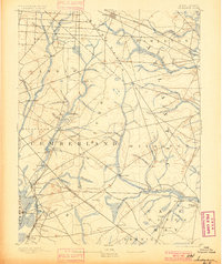
1893 Map of Tuckahoe
USGS Topo · Published 1900About this map
Industrial vestiges of the early Pine Barrens iron and timber economy are evident throughout this landscape, most notably at the Old Etna Furnace and Monroe Forge. The region is defined by its intricate drainage system, where the Tuckahoe River and Maurice River serve as primary arteries for commerce and transit. Small mill settlements such as Bennett Mill, Fries Mills, and Heaters Mill dot the interior, typically situated where branches like Manantico Creek or Manumuskin Creek provided reliable water power. Transportation is anchored by the West Jersey Railroad, which connects established river towns like Port Elizabeth and Mauricetown to the broader rail network. The map reveals a transition between the uplands of Buena Vista and the coastal reaches of Upper township, highlighting the importance of family-named landmarks like Hance Bridge and Marshallville in nineteenth-century South Jersey life.
Find a feature on this map
68 named features on this map. Tap any name to fly to it.
Don’t see what you’re looking for? This feature index may not catch every label — zoom into the map to look around manually.
Map Details
Editions of this 1893 Tuckahoe Map
4 editions found

Other maps of this area

1884 · Sea Isle
USGS Topo · 1:62,500

1888 · Dennisville
USGS Topo · 1:62,500

1888 · Sea Isle
USGS Topo · 1:62,500

1890 · Great Egg Harbor
USGS Topo · 1:62,500

1890 · Hammonton
USGS Topo · 1:62,500

1890 · Tuckahoe
USGS Topo · 1:62,500

1890 · Maurice Cove
USGS Topo · 1:62,500

1890 · Bridgeton
USGS Topo · 1:62,500

1890 · Mullica
USGS Topo · 1:62,500

1890 · Glassboro
USGS Topo · 1:62,500